


Native connections to the Earth abound in the American West.
Whatever creation story you subscribe to, there was a beginning, and in that beginning, there was land — and the people who inhabited it. Whether or not we as individuals or members of a particular race or nation are aware of how and where we began, there is, nonetheless, that beginning. Those of us who are descendants of the first inhabitants of North America are fortunate in that we seem to be aware of our origins. We are also aware that those origins, more often than not, are connected to a place.
For thousands and thousands of years prior to European arrival, people inhabited every part of North America, from the frozen tundras of the Arctic to the steamy jungles of Mesoamerica. Everything needed to survive in a primitive lifestyle came directly from the physical environment. Edible fruits and vegetables and most animals — small and large, walking on the land, flying in the air above it, or living in the rivers and lakes — served as food. Many animals not only were the source of sustenance, they were also the raw material for clothing, shelter, tools, and weapons. Plants were a source of medicine, material for cordage, teas, insulation for winter clothing and shelters, and water. Trees provided materials for homes, tools, weapons, household accouterments, medicines, and winter horse feed. Dwellings were also made of soil and stone, or carved into stone. Stones of various types were used to make knife blades, tools, and projectile points. In short, the land provided; the environment enabled and sustained life.
As Native peoples moved beyond mere survival and many cultures began to thrive, there came an opportunity to consider their relationship with the land — its importance, habits, whims, and cycles. Practical knowledge evolved into intimate understanding. Eventually there developed an emotional and spiritual connection to the environment, and that connection led to beliefs and philosophies that shaped the hundreds, if not thousands, of Native cultures throughout the continent.
Central among those philosophies is the belief that the land is sacred and to be treated as such. It is our beginning. It is our source and our sustenance. It is the mother — in fact and in spirit. Our connection to that reality is represented in origin and creation stories, as well as stories of rebirth and affirmation. Almost without exception, each of those stories is associated with a place — be it a mountaintop, a hill, a valley, a cave, or a river. And each such place is sacred.
Indigenous North Americans occupied the length and breadth of this continent, so it is no surprise that sacred places are everywhere and numerous, likely numbering in the thousands. Many, of course, have been forgotten over time, and many remain in the margins of collective memory. Fortunately, not all have been forgotten.
The numerous sites have a particular, significant role in the history, culture, spirituality, and mythology of each Native tribe or nation. Furthermore, the separate clans, bands, or communities that comprise a nation or tribe may each have a place or area they consider sacred.
Each of the more than 500 ethnically identifiable indigenous nations still in existence has at least one origin story and many, many stories explaining a profound connection to the land. Consequently, all of us currently inhabiting the land — no matter our ethnicity or race — walk on sacred land or pass a sacred site frequently, if not every day, whether we are aware of it or not. None of those sites is more or less sacred than any other, and none of those stories is more or less compelling than any other. Each has a significance bound up with the tribe’s stories and history. Unfortunately, many sites are in legal limbo or have been altered by the encroachment and development of modern society; that, however, does not diminish their significance in the eyes and hearts of Native people.
Following are 12 sites within the boundaries of the United States sacred to at least one indigenous tribe or nation. Some are well-known, others are not. Some of the tribes or nations associated with them still exist, some are no longer with us.
They are presented as examples — a scant dozen meant to represent myriad sacred sites that are part and parcel of the beauty and magic of the continent, and especially the West. Not all of these sites are readily accessible, some are extremely difficult to get to by any motive means, and some are not accessible to anyone but members of the tribes or nations who own them or are connected to them. Whether they were constructed or altered, as small as an obscure waterfall or as monumental as an entire mountain, these sacred places are the other part of identity for people who knew the land, respected it, and loved it as a relative.
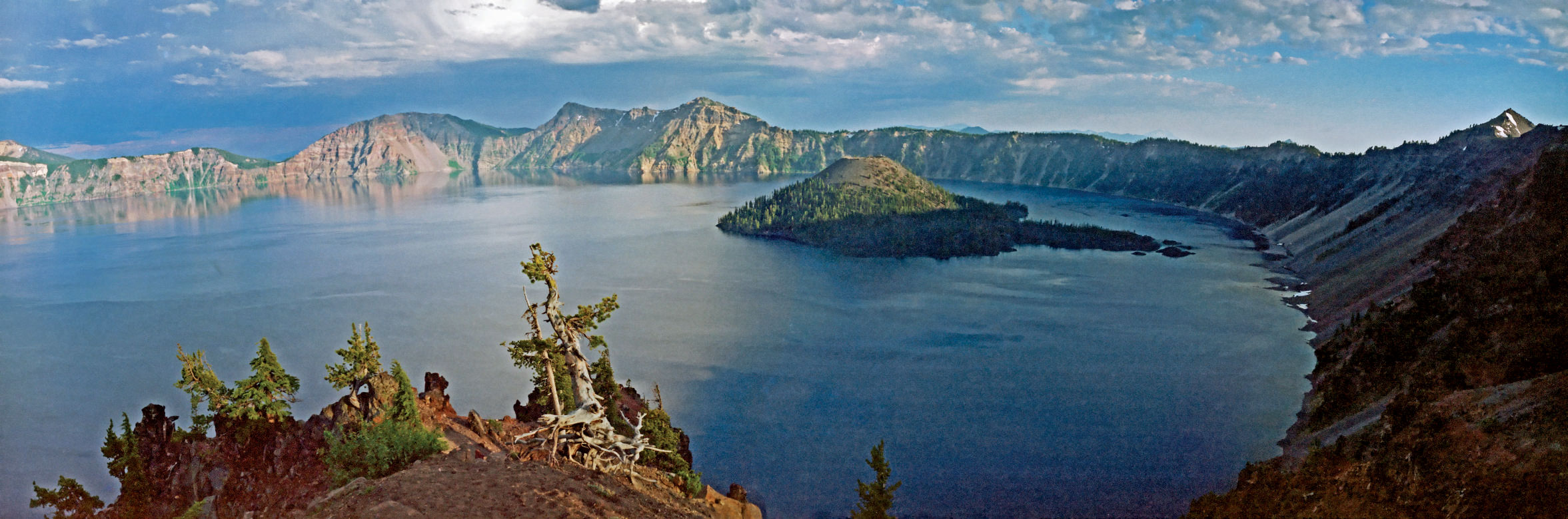
Crater Lake, Oregon
More than 7,500 years ago, a volcanic eruption blew the top off Mount Mazama and Crater Lake was formed. To the Klamath people, it was the site of an epic struggle between the ruler of the upper world and the ruler of the lower world. When Skell of the upper world defeated Llao of the underworld, Llao’s home, Mount Mazama, was destroyed. The mountain has been revered by Native peoples since their ancestors witnessed the catastrophic eruption and collapse thousands of years ago. Today the site is used for vision quests as well as feats undertaken to prove endurance and courage.
Blue Lake, New Mexico
High in the mountains of northern New Mexico is a body of water called Blue Lake. For nearly 65 years it fell under the legal control of the United States government as part of Carson National Forest. Under the Nixon administration it was returned to the Taos Pueblo in 1970. Even during the lake’s temporary stint as federal property, the Taos Pueblo people never lost their reverence for and connection to it. Such a lapse would have been impossible: The Taos people hold the spiritual belief that they originated from the lake.
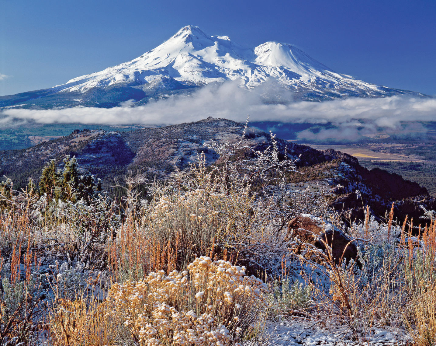
Mount Shasta, California
For thousands of years, several different tribes considered this snow-covered mountain in the Cascade Range of Northern California the center of creation; it was at the axis of territories controlled by the Shasta, Wintu, Modoc, and the Pit River tribes, and those tribes certainly lived in its shadow. The mountain also figured in the lore of the Karuk, Hupa, and Upper Klamath peoples. Eventually, with the first Euro-American contact in the 1820s, the white man discovered the area, along with its geographic grandeur and rich, ancient mythologies.
Cahokia Mounds, Illinois
A thousand years ago or so, as many as 20,000 people lived and thrived in a great city along the Mississippi River, just east of modern-day St. Louis.
Here in the rich bottomland of the Mississippi, a civilization of Mississippian peoples thrived, developing from small settlements in A.D. 700 to a complex chiefdom by A.D. 1000. One of the greatest cities in the world in its heyday and the most sophisticated prehistoric Native civilization north of Mexico, it was larger in A.D. 1250 than the London of the day. Mound-building, which began about A.D. 900, had made it a city of great monuments; some of the more than 120 mounds (only about 80 still exist) rivaled those of the Inca and Maya in size. The central ceremonial focus of these is Monk’s Mound — at 100 feet high, 1,050 feet long, and 964 feet wide, it is the largest man-made earthen mound in the Americas. Constructed like the other mounds of basket-transported soil and clay, Monk’s Mound at its base is actually larger than the Great Pyramid at Giza (roughly 14,000 acres).
The mound metropolis of Cahokia was abandoned for unknown reasons by A.D. 1400 — climate change and declining resources have been postulated — but it likely remained a significant influence on many cultures that came later on the plains, including the namesake Cahokia subtribe of the Illiniwek (or Illinois) Tribe, who came to the area in the 1600s and were living nearby when the French arrived in about 1699.
Black Hills, South Dakota
The Lakota language has two names for these isolated mountains: Paha Sapa and He Sapa. The former gives a word picture of the dark impression the sacred mountains make from a distance; the latter describes what they look like close up. The region that rises from the plains in western South Dakota and northeastern Wyoming was believed to be a temporary resting place for the spirits of departed braves, who would hunker down for a while in the afterlife till they were acclimated enough not to be blinded by the spectacular sight of the happy hunting grounds. To the Lakota it was, and is, the Heart of All Things. Interestingly, a space-shuttle astronaut who photographed the Black Hills from Earth’s orbit reported that the outline of the mountains resembles the shape of a human heart.
It might well look like a broken heart. Inyan Kaga Mountain is particularly sacred to the Lakota — that did not stop one of Gen. George Custer’s officers from climbing to the top and carving the general’s name there in 1874 during an Army mission to assess the area’s mineral resources. In 1877, the U.S. government reneged on the Treaty of Fort Laramie and seized the land. After numerous failed attempts to regain the land in the courts, Indians with ancestral claims to the Black Hills had something of a victory in 1980: The Supreme Court held in United States v. Sioux Nation of Indians that the Black Hills had been taken illegally and remuneration of the initial offering price plus interest had to be paid ($17.1 million for the market value of the land in 1877 and $88 million in 5-percent-per-annum simple interest between 1877 and 1980). The Lakota, who wanted the Black Hills rather than the payoff, refused the money, which remains in an interest-bearing account now valued at almost $900 million. To take the money, the Lakota believe, would be to validate the seizure of their sacred land.
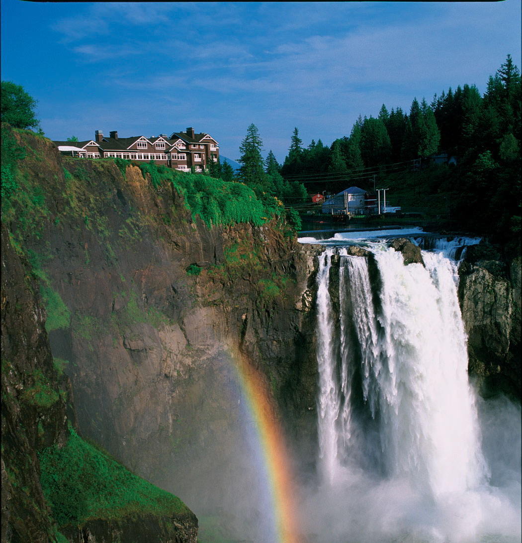
Snoqualmie Falls, Washington
Between Snoqualmie and Fall City in western Washington, the Snoqualmie Falls plunge an impressive and misty 268 feet. The site derives its popular fame both for its beauty and for its appearance in the television show Twin Peaks. For the Snoqualmie people, however, this dramatic waterfall is a focal point of spirituality and culture. The mists rising from the base of the waterfall are believed to connect heaven and earth; they are also thought to convey prayers to the Creator. In Native tribes indigenous to the area, this is where First Woman and First Man were created by Moon the Transformer. The scene of origin, it is also a traditional burial site.
The spiritual power of the falls is matched by literal power: Puget Sound Energy currently operates two hydroelectric power plants there; nonetheless, it remains one of Washington State’s biggest tourist attractions, drawing more than 1.5 million visitors a year. A 2-acre park, hiking trail, observation deck, and gift shop (not to mention the power plants) have changed the character of the place but not the essential beauty and sacred nature of the land to the Snoqualmie, who have lived for centuries in the Snoqualmie Valley.
Bear Lodge, Wyoming
Many tribes had different names for it — Bear Lodge, Tree Rock, Ghost Mountain, Bear Tipi, and Bear Lair, among others. In Lakota, it is Mato Tipila. It is probably more familiar to most non-Native people as Devils Tower. Rising 1,267 feet out of the surrounding terrain above the Belle Fourche River in northeastern Wyoming, the monolith’s summit is 5,112 feet above sea level. It was declared a national monument in 1906 by Teddy Roosevelt, but ages before that it engendered many a Native story. In one reality it is the core of an ancient volcano; in another it is the site connected to the origin of peoples and their ceremonies of prayer and renewal. At least 20 different tribes regard the site as a sacred place and continue to conduct sweat-lodge ceremonies, vision quests, and sun dances here as they have since before recorded history.
Legend has it that the great Cheyenne hero Sweet Medicine, who brought the Four Sacred Arrows to the tribe, died and is buried near here. As he lay dying in a hut by Bear Lodge, Sweet Medicine prophesied that the old ways and the buffalo would disappear and be replaced by “Earth Men” who would fly above the earth, take thunder from light, and dig up the earth and drain it until it was dead. It is said the Four Sacred Arrows are in a sanctuary in a secret cave on the south side of Bear Lodge.
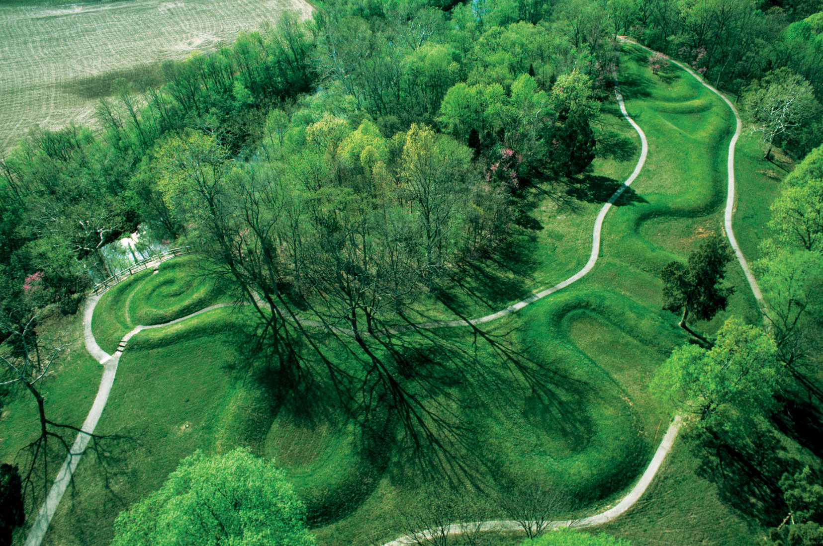
Great Serpent Mound, Ohio
Its tail still slightly coiled, the earthen snake undulates more than 1,300 feet to its head with mouth open and pointing in the direction where the sun sets on the summer solstice. The largest effigy mound yet discovered, the Great Serpent Mound in south-central Ohio is believed through carbon dating to have existed as far back as 2,000 years ago. Once shrouded in woodland, the now-exposed mound remains shrouded in uncertainty.
The Great Serpent Mound of Ohio first came to the attention of the country with the new Smithsonian Museum’s publication in 1848 of Ancient Monuments of the Mississippi Valley by Ephraim Squire and Edwin Davis. It was unknown then and it is unknown now what indigenous group or groups constructed the artistic mound and for what reason; the Adena, Hopewell, and Fort Ancient cultures, all of which were known for earthworks, are possibilities. Did the site once have large totemic shrines to a legendary serpent? Were great ceremonies conducted there? Is there astronomical significance to the mound’s placement? No one knows. Today, the Great Serpent Mound, a National Historic Landmark owned by the Ohio Historical Society, is managed in a park by the Arc of Appalachia.
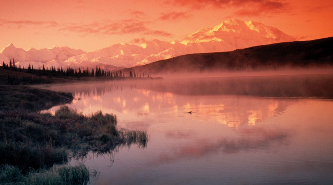
Mount Denali, Alaska
In ancient times, likely as far back as 12,000 years, hunter-gathers lived, at least seasonally, in the region surrounding the highest mountain in North America. They must have marveled at the 20,320-foot-high peak just as visitors to Denali National Park do today. The prehistoric residents traveled and traded in the peak’s vicinity. To the Dena’ina, Ahtna, Lower Tanana, Koyukon, and Upper Kuskokwim, the mountain they call “the High One” or “the Great One” is still sacred. Native Americans who live in the mountain’s long shadow believe it has supernatural powers.
Bighorn Medicine Wheel, Wyoming
At a desolate 9,642 feet in the Bighorn Mountains of north-central Wyoming is a medicine wheel made of stones. Twenty-eight spokes — which likely coincide with the days of the lunar cycle — radiate from a central cairn of stones piled about 2 feet high out to an outer rim about 80 feet in diameter, 245 feet in circumference. Six smaller cairns are spaced along the outer rim. As late as 1922 a buffalo skull sat atop the central cairn but has since disappeared. The wheel is thought to have been constructed by Plains Indians between 300 and 800 years ago. Over the ages, the Bighorn Medicine Wheel has come to have spiritual significance for many different tribes and is used primarily by many as a site for vision quests. It is said that the great Nez Perce leader, Joseph, came to the site to pray, and prayer offerings are left there even today.
Great Mother Mound, Mississippi
More properly, it might be called Great Mother Mounds, with an S. Known as Nanih Waiya, Choctaw for “leaning hill,” the mysterious mound area along Mississippi’s Winston-Neshoba county line is venerated by the Choctaw and Chickasaw tribes for the creation and migration legends the mounds are central to.
There are two main mounds, roughly a mile apart, both considered sacred. One is a hill containing a water-filled underground cave; the other, a flat-topped earthen platform about 35 feet tall, 140 feet wide, and 220 feet long. It isn’t known which is the Great Mother, but origin stories tell of the first people emerging wet from the cave and lying on the hillside to dry themselves. According to one version of the migration story, a holy man led his people east looking for a new place to live. They traveled a long time, always going in the direction indicated by a pole that the holy man stuck into the ground every night. One night the stick burrowed deep into the earth and stood straight up — a sign to end their migration. There the people made their new home.
Surface artifacts indicate that the site literally was home as early as A.D. 100 and was inhabited till about A.D. 700. For some years, the area surrounding the archaeological mound was a Mississippi state park; it was returned to the Mississippi Band of Choctaw Indians in 2006.
Pipestone National Monument, Minnesota
On the Mountains of the Prairie / On the great Red Pipe-stone Quarry, / Gitche Manito, the mighty, / He the Master of Life, descending, / On the red crags of the quarry / Stood erect, and called the nations, / Called the tribes of men together.
So wrote Henry Wadsworth Longfellow in The Song of Hiawatha of the area in southwestern Minnesota where American Indians have quarried the beds of red-colored claystone for ceremonial pipes for as long as 3,000 years. Native legend tells the story its own way: Long ago the Great Spirit took the form of a bird and showed the people the red stone that was his flesh. He made a pipe from it and smoked it and told them it was a way to connect to him. For thousands of years, people of many different tribes journeyed to the site on the edge of the northern plains, now in Minnesota, to quarry the red stone. It is done to this day. From the soft stone, now called catlinite, pipe bowls are carved for ceremonial use. The site continues to be sacred to many tribes. In ancient times as now, it was a place of peace, and the pipes carved from its stone are known to the white man as peace pipes.
In addition to books on Lakota history, Joseph Marshall III’s works include The Power of Four: Leadership Lessons of Crazy Horse (Sterling, 2009) and Keep Going: The Art of Perseverance (Sterling, 2006).
From the November/December 2009 issue.


