


Celebrate the National Park Service's centennial by going on a bucket list-worthy adventure.
We've put together a list of seven things to do in our favorite national parks coast to coast. Or check out our top 15 national parks, our sequel list toppers, or these 10 parks that are also worth a summer visit.
Walk Around a Big Mountain
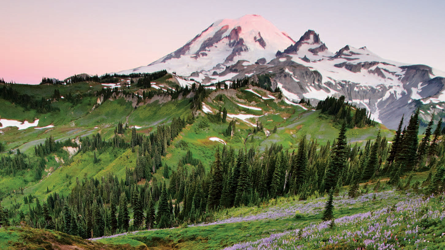
Wonderland Trail, Mount Rainier National Park, Washington
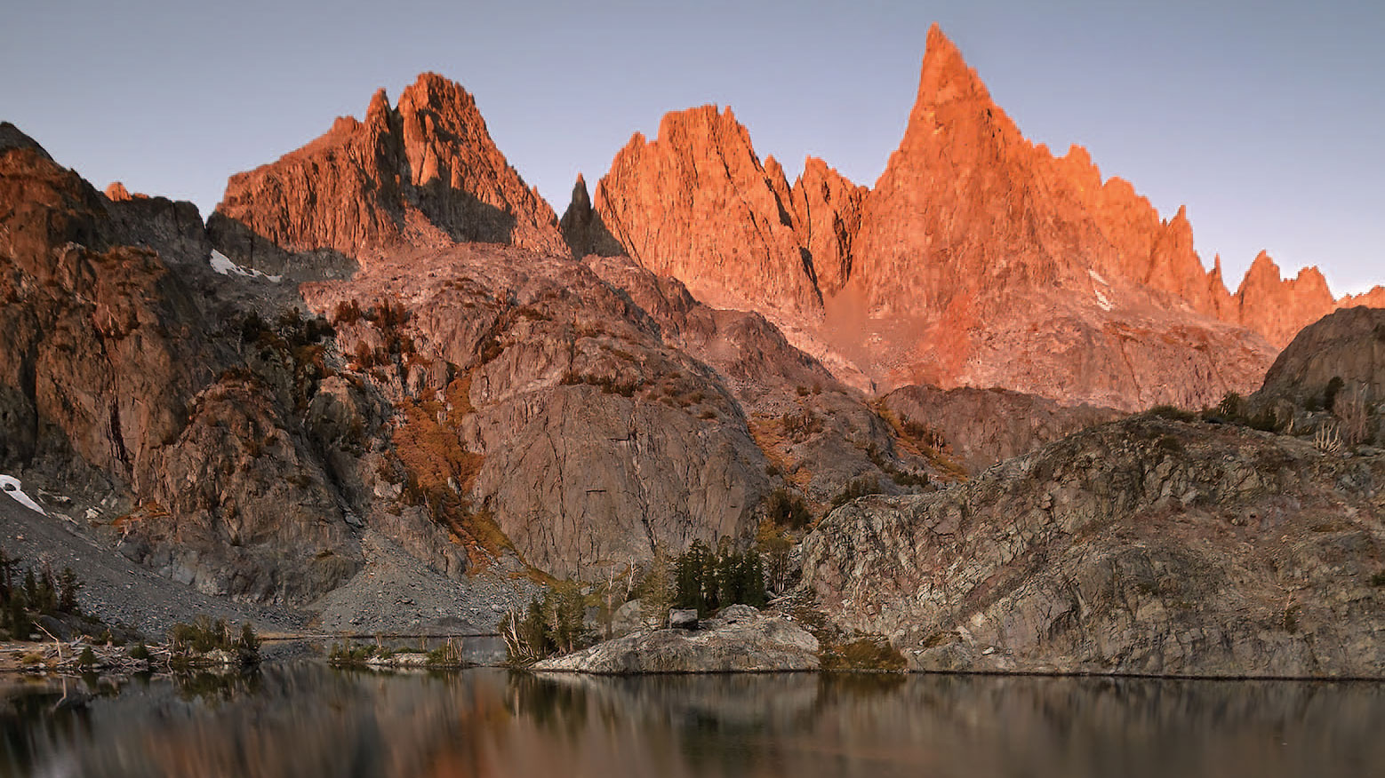
Summiting a big mountain is an obvious enough bucket-lister — especially if that mountain is named Rainier. Washington’s highest point and the country’s premier glaciated peak is a rite of passage for climbers and Himalayan dreamers of all stripes. But if there was ever a reason to forego a 14,410-foot summit push and circumnavigate a hulking icy rock instead, it would surely be on Mount Rainier’s equally checklist-worthy Wonderland Trail.
Encircling Mount Rainier (a volcano encased in more than 35 square miles of snow and ice), the legendary 93-mile trail undulates through some of the most dramatic wilderness imaginable within a short drive from a major city. What’s out there? Old growth forests of Douglas fir, cedar, and hemlock. Subalpine meadows carpeted in avalanche lilies, lupine, and Indian paintbrush. Torrential glacier-fed rivers. And unbeatable vantage points of the famous peak from all sides.
Doing the full Wonderland Trail (many visitors opt for portions of it) is solid proof that hiking all the way around a mountain can be at least as challenging as clambering up it. July through September are the warmest, sunniest months, though rain and snow can happen at any time along a path with over 20,000 feet of elevation gain/loss through rugged terrain and famously mercurial Pacific Northwest weather.
The National Park Service recommends a minimum of 10 days, but preferably two weeks, to complete the entire route — which is divvied between 18 trailside camps and enough ups, downs, and endless hairpin switchbacks to feel like its own sort of Everest less than 100 miles from Seattle.
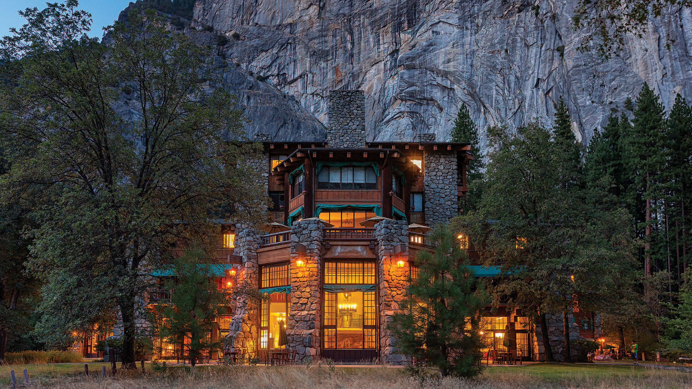
Check Into The Majestic Yosemite Hotel
Yosemite National Park, California
If you build it, they will come. That was the thinking of National Park Service Director Stephen Mather back in the 1920s when Yosemite Valley, once the home of a thriving Native Miwok community, awaited its next wave of distinguished guests: well-heeled leisure travelers from back East.
The only way to get these folks to make the pilgrimage to this Shangri-La of glacial-carved peaks, towering granite walls, and nearly half-mile-long waterfalls, he figured, was with a magnificent lodge that somehow lived up to the miraculous setting.
One marvel of engineering and the largest trucking endeavor of its day later (more than 5,000 tons of stone, 1,000 tons of steel, and 30,000 feet of timber hauled over onerous mountain roads), The Ahwahnee hotel (recently renamed The Majestic Yosemite Hotel due to a legal disupte) was built. And people came. The yardstick of all national park lodges ever since, The Ahwahnee (Miwok translation: “large, gaping mouth” — a description of the valley) has welcomed generations of dazzled park guests, from royalty and presidents to the rest of us.
Taking high tea by the huge roaring fireplace in the Great Lounge after an afternoon hike to Mirror Lake. Savoring a meal in the lodge’s equally grand dining room, with its giant gabled ceiling, sugar-pine trestles, and enclosure of floor-to-ceiling windows. As far as Yosemite Valley traditions go, these are about as big as those 3,000-foot granite cliffs hulking out in the backyard.
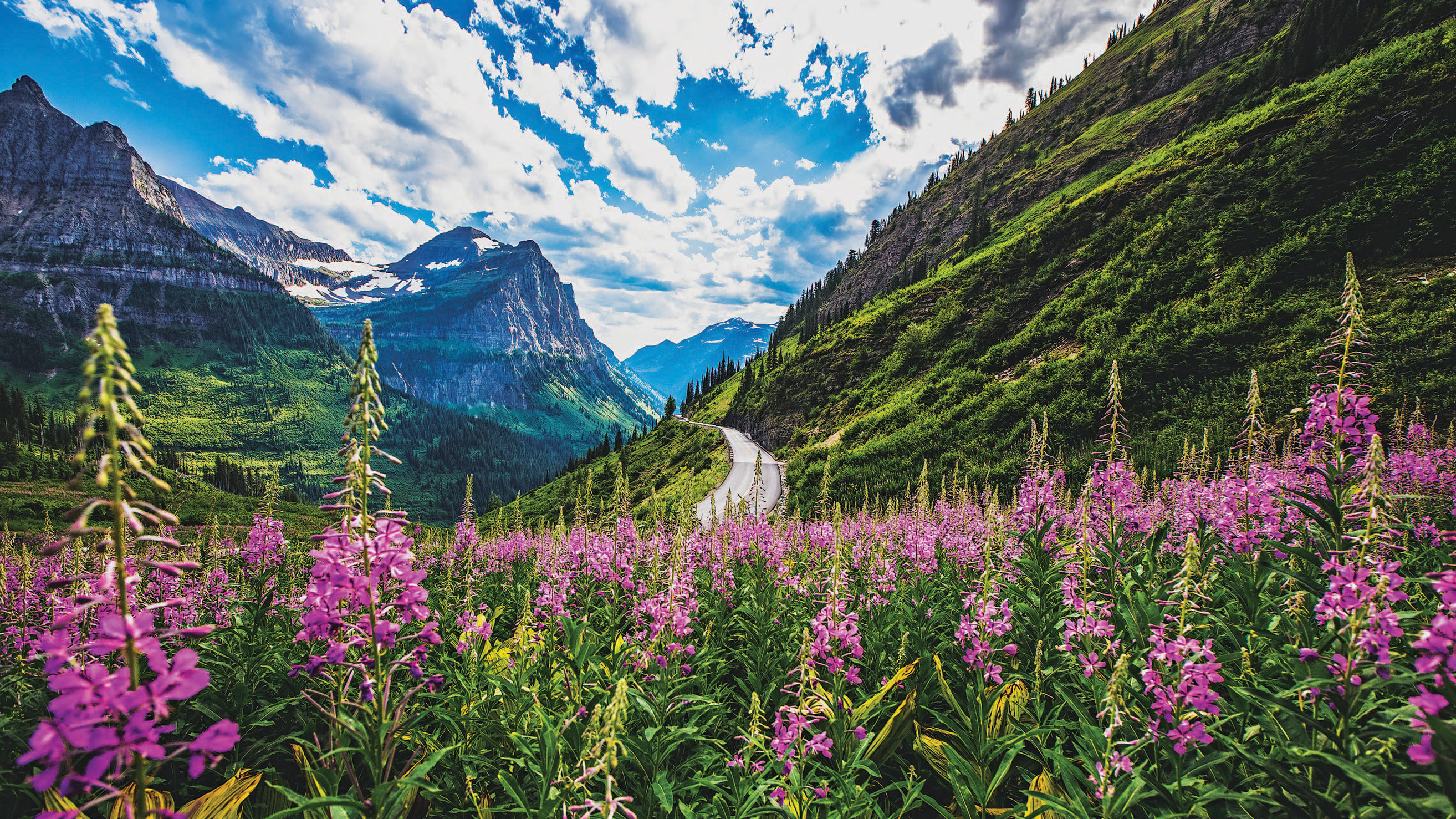
Do the Ultimate Mountain Drive
Going-to-the-Sun Road, Glacier National Park, Montana
Dazzling mountain drives grace many a great American range, from Colorado’s Trail Ridge Road in the central Rockies to Virginia’s Skyline Drive in the Appalachians, from New Hampshire’s Mount Washington Auto Road in the Whites to Washington state’s Hurricane Ridge Road in the Olympics.
But there’s only one Going-to-the-Sun Road — our vote for the nation’s most bucket-listable white-knuckler, straddling the Continental Divide in northern Montana’s sublime Glacier National Park. Early homesteaders were the first eco-tourism pioneers, hauling visitors by wagon into this stunning Rocky Mountain backcountry in the late 1800s — well before the area’s designation as Glacier National Park in 1910. Spurred by the nation’s first auto travel wave, one of the most ambitious trans-mountain roads ever was soon in the works. In July 1933, after more than two decades of planning and construction, the park officially celebrated the completion of Going-to-the-Sun Road. The name was borrowed from the park’s Going-to-the-Sun Mountain — a nearby peak where, according to Blackfeet legend, a god who came to earth to inspire young braves found his portal back home to the sun.
More than 80 years and several rehabilitation projects later, the 50-mile, at-times precipitous two-laner (fully open during summer months and into October, weather and roadwork permitting) continues to awe, fray the odd nerve, and draw crowds of gawkers at 6,646-foot Logan Pass, where the Continental Divide meets astonishing Big Sky panoramas. Onward it winds — past waterfalls, vast snowfields, and sweeping glacial valleys in an overwhelmingly vast and rugged landscape that the Blackfeet have aptly called the “Backbone of the World.”
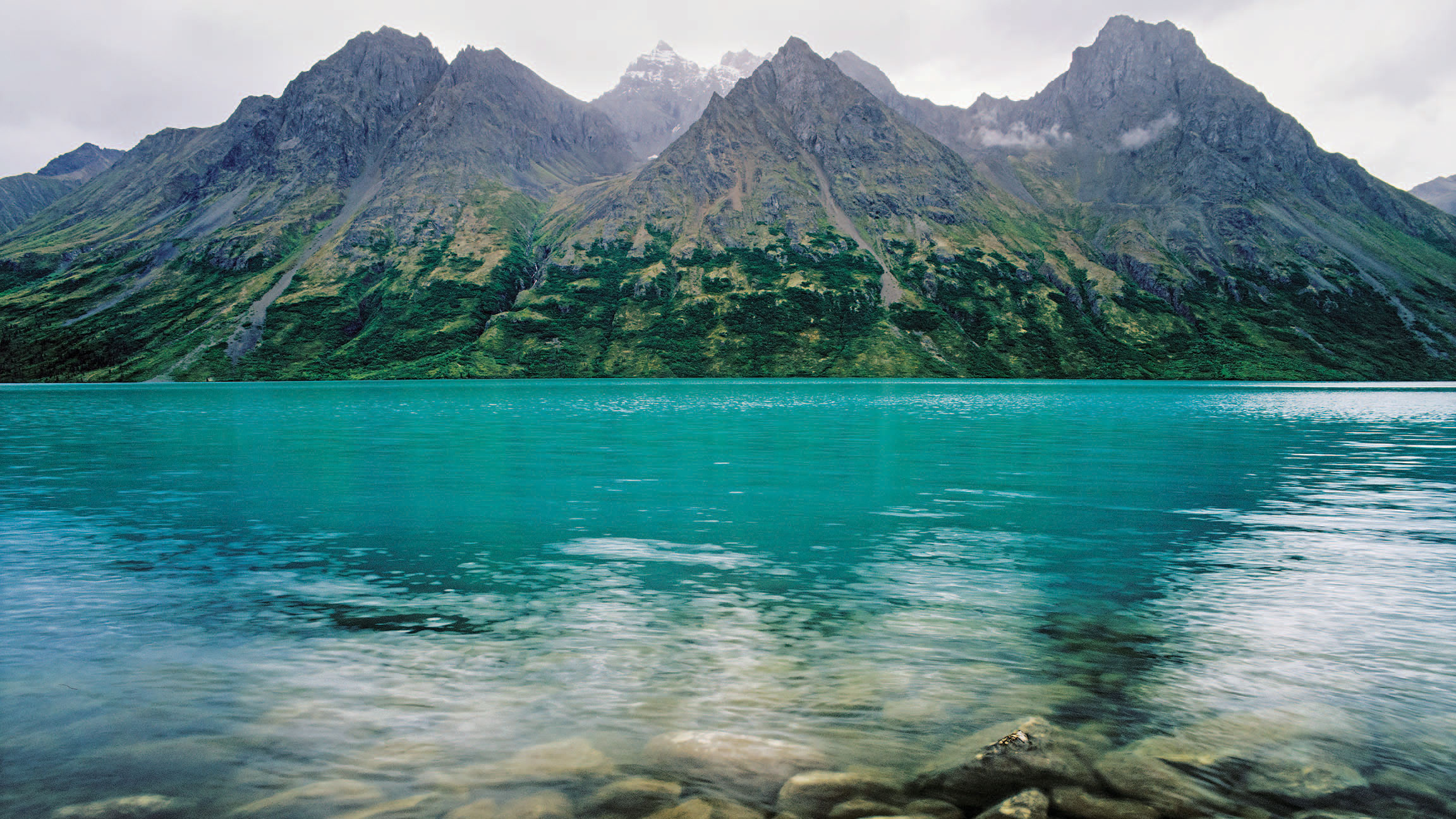
Disappear Into the Alaskan Wilderness
Lake Clark National Park and Preserve, Alaska
Just getting to Alaska’s Lake Clark National Park and Preserve is a bucket-list voyage in itself: Fly to Anchorage. Connect with a twin-engine air taxi for a 60-minute flight to park headquarters at Port Alsworth. Squeeze inside another puddle jumper to a put-in spot somewhere in those 4 million acres of the most underappreciated Alaskan wilderness on the national park grid. But this is only where it begins.
What’s waiting for the intrepid park explorer out there? Alpine imagery that picks up where the northern Rockies leave off. Salmon-filled rivers and pristine glacial lakes patrolled by grizzlies. Waterfalls, rolling tundra foothills, and more than 900 square miles of glaciers. A historic Native Dena’ina Athabascan trail that hasn’t seen much traffic over the last couple centuries.
Hiding on Upper Twin Lake like a mirage is the fabled homesteader cabin of legendary naturalist Dick Proenneke, who lived out here alone for 30 years. Today, the hand-built abode remains one of Alaska’s most far-flung pilgrimage sites.
Best of all, you have this whole place virtually to yourself. Lake Clark sees about 17,000 visitors annually — a tiny fraction of the crowds herding into the most popular national parks thousands of miles away from these parts.
Once you get there, just set off. Wherever and however you want. On foot. In a kayak. By raft. With fishing gear. But with a topo map, compass, and some wilderness savvy, to be sure. Booking a reliable guide like veteran outfitter Alaska Alpine Adventures for a customized paddling and hiking trip is another wise move in a place like this.
Take a Hike That Would Make John Muir Proud
The John Muir Trail, Sierra Nevada Mountains, California
“Thousands of tired, nerve-shaken, over-civilized people are beginning to find out that going to the mountains is going home,” John Muir wrote more than a century ago in Our National Parks. Is there any doubt which mountains inspired these words from the legendary conservationist and Sierra Club founder?
The 211-mile John Muir Trail — aka the most dependably spectacular mountain route in the West — rambles along California’s Sierra Nevada from Yosemite National Park to the summit of Mount Whitney. Rising over snow-dusted, 13,000-foot passes. Skirting beneath rows of gorgeous, craggy peaks. Crossing breezy meadows and forested river valleys through some of the country’s most famous national parks and preserved wilderness areas. No trail better lives up to its name.
If doing the whole JMT in one three- to four-week ramble doesn’t exactly jibe with your reality, consider an abridged version. Favorite sections of the trail (overlapping the 2,660-mile Pacific Crest Trail much of the way) include the northern portion from Yosemite’s Tuolomne Meadows through the Ansel Adams Wilderness to Devils Postpile National Monument and Mammoth Lakes. A longer, more demanding trek at the southern end from Bishop Pass to Mount Whitney features the magnificent Rae Lakes area, beautiful Palisade Peak, and a summit shot at the highest point in the lower 48.
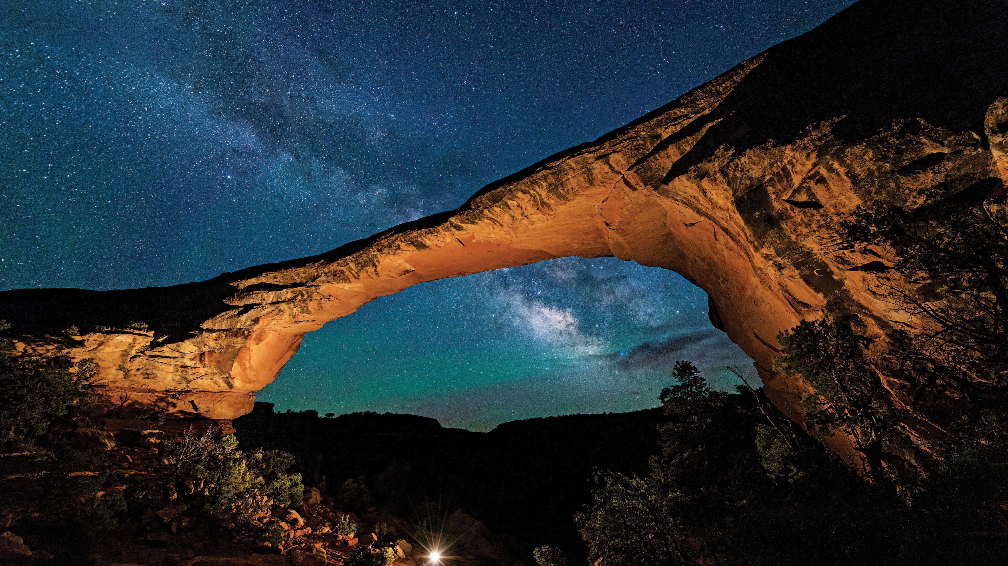
Stargaze America’s Darkest Sky
Natural Bridges National Monument, Utah
Utah’s Natural Bridges National Monument is one of the best places anywhere to see stars. Officially.
Hiding in the preternaturally dark shadow of better-known national park neighbors like Zion, Bryce, and Canyonlands, Natural Bridges became the world’s first International Dark Sky Park on March 6, 2007. Here you’ll find a rare Bortle 2 sky — on a nine-level scale measuring relative observability of celestial objects from the most light-polluted cities (class 9) to virtually unattainable darkness (class 1).
“We’re currently one of the three darkest park units in the continental United States, sharing honors with Nevada’s Great Basin and Big Bend down in Texas,” says Ted Hodson, a Natural Bridges ranger and astrophotographer who leads astronomy and stargazing programs at the park between May and September. “Barring clouds, which are very rare up here, I can see the Milky Way every single night.”
The park’s remote high desert location — perched at 6,500 feet, 35 miles from the nearest town on the other side of a 7,000-foot ridgeline for safe measure — provides a sky as pristine as it was a thousand years ago, long before light and pollution had anything to do with each other.
“As far as darkness goes, these are the same night skies the Ancestral Puebloans were gazing up at right here,” Dodson says. “Except for the odd plane flying overhead.”
Best star viewing at Natural Bridges is between late June and early July — when the earth is facing the galactic center and the Milky Way is at its thickest, Dodson explains. For the season’s most dramatic celestial event, come in the early fall when the Leonid meteor shower erupts. “It’s incredible,” Dodson says. “It just rained fire last year.”
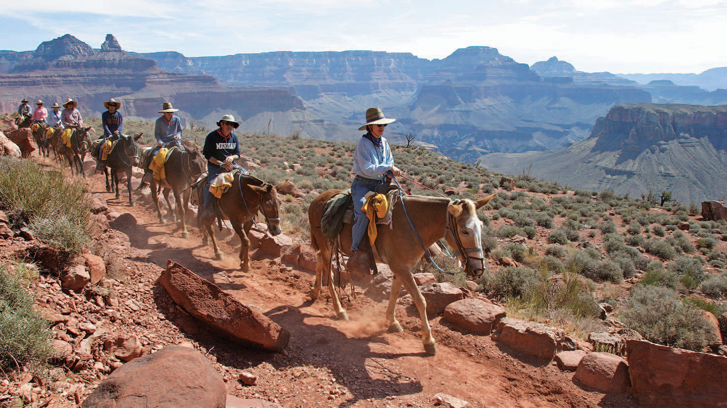
Ride a Mule From Rim to River
Grand Canyon National Park, Arizona
Most of Grand Canyon National Park’s audience of nearly 5 million annual visitors make it as far as a quiet gape from park headquarters at the South Rim. From up here, the world’s most famous fissure is a surreal still life. Its chisel, the mighty Colorado River, hides a vertical mile below, thick as a bootlace if it can be seen at all.
Descending into this 6-million-year-old inner sanctum is an entirely different Grand Canyon experience. Winding down its endless switchbacks, beholding 2 billion years of exposed rock up close, crossing a narrow bridge over the coursing Colorado. It’s one of the greatest journeys one can make on two sore feet. Or better yet — aboard four steady hooves.
Since the late 1800s, mules have been the premier mode of transport in and out of the Grand Canyon. It’s one of the few places in the American West where the reliable, respect-deprived Rodney Dangerfield of equines outshines its spotlight-stealing cousin — the horse. And from where you’re sitting, it’s the ride of a lifetime.
South Rim mule trips (subject to certain age, height, and weight restrictions) can and should be booked up to 13 months in advance through park concessionaire Xanterra Parks & Resorts. The journey descends from the South Rim along the canyon’s 10.5-mile main artery, Bright Angel Trail, with a lunch break at lovely Indian Garden midway down, followed by a steak dinner and cozy night at the legendary Phantom Ranch retreat on the canyon floor. The following morning, after a hearty breakfast, it’s all the way back up along the slightly shorter, steeper South Kaibab Trail.
See those sweaty, red-faced huffers and puffers pounding the trail below you? They have your deepest sympathies.
See the rest of our 2016 Adventure Bucket List.
From the May/June 2016 issue.


